Preserving Libraries in the Sand
Interdisciplinary partners at UC San Diego are using drones and 3D-modeling to save Puerto Rico’s indigenous history from the sea.
In the aftermath of Hurricane Maria in late 2018, Eric Lo, an engineer affiliated with the Cultural Heritage Engineering Initiative (CHEI) at the UC San Diego Qualcomm Institute, touched down in Puerto Rico with a single goal: find the ancient archaeological site he had helped monitor for more than a year and assess the damage.

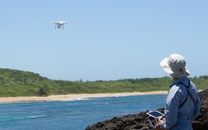
Engineer Eric Lo operates a drone at Hacienda La Esperanza Nature Reserve, Puerto Rico.
Lo had visited only a few months prior, before Hurricane Maria struck, to collect drone imagery as part of an interdisciplinary effort to recreate the site digitally. Under the careful eyes of the non-profit Para la Naturaleza and Isabel Rivera-Collazo, an assistant professor and environmental archaeologist with UC San Diego’s Department of Anthropology and the Scripps Institution of Oceanography, the excavation of this abandoned settlement had provided new insight into the lives of Puerto Rico’s indigenous people, the Taíno.
Now Lo was returning again, this time to determine how the site had fared against a Category 5 hurricane with wind speeds topping 170 miles per hour.
‘Libraries of Knowledge Washing Away’
The former Taíno settlement lies on the island’s northern coast, on Hacienda La Esperanza Nature Reserve. Since 2017, Lo has visited the site through a partnership between Rivera-Collazo, project lead, and Professor Falko Kuester, a computer scientist and structural engineer, and director of CHEI. As a CHEI engineer, Lo is a member of a team that creates striking, digital 3D surrogates of culturally important buildings and spaces to create a record that can outlast earthquakes, fires and other natural disasters. When CHEI engineers partnered with Rivera-Collazo’s team in 2017, they had already worked to unearth a range of historic sites through 3D visualizations, among them an underwater cave replete with prehistoric fossils and the historic Baptistery di San Giovanni in Florence, Italy.
The team’s goal is similar on Puerto Rico: to create digital, 3D surrogates of the island’s archaeological sites using drone sensor data and big-data analytics. Documenting this aspect of Puerto Rico’s cultural history could preserve local knowledge, indigenous heritage and a communal sense of belonging, says Rivera-Collazo, especially in a changing landscape. Moving forward, the key will be to use these 3D digital “twins” of real archaeological sites to identify which are most vulnerable to hurricanes, erosion, sea level rise and climate change.
“Libraries of knowledge are washing away with the waves,” said Rivera-Collazo. “What we are trying to do is preserve that knowledge and understand how it could be affected by change in the coastal environment, so we can have a better idea of which sites need the most protection.”
As sea levels rise, threats to the coastal environment from erosion and storm surges during hurricanes could grow worse. Archaeological sites dating back nearly 5,000 years, around the beginning of construction on Stonehenge and the founding of the city of Troy, could be submerged by floodwaters or washed out to sea. Identifying the most vulnerable of these sites would be a first step toward saving them; with a comprehensive, digital archive of the island’s archaeological history, Rivera-Collazo says, local communities can feel empowered to nominate these sites for heritage preservation.
Conserving an Ancient History for the Future
Lo arrived in Puerto Rico a month after Hurricane Maria made landfall, in a landscape taking shaky steps toward recovery. The home where Lo was staying had electricity, but stoplights in the surrounding area still blinked on and off, and finding a functioning gas station was a game of chance.
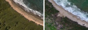
The archaeological site itself looked completely different. Before Hurricane Maria, the land had been an open, grassy area marked by flourishing trees. In the storm’s wake, trees had been toppled and stripped of their leaves, and the open space lay beneath a suffocating layer of mud. Thanks to a cleanup effort led by officials at the nature preserve, the environment was beginning to bounce back — grass was becoming visible again, and trees were growing new leaves — but the site had clearly been hit hard. A before-and-after comparison of Lo’s drone imagery confirmed what he had seen on the ground.

A beach at the Hacienda La Esperanza Nature Reserve, before and after Hurricane Maria.
“Seeing the difference in the coastal land mass that is exposed before Maria and after Maria was pretty shocking,” Lo said. “It’s the sort of thing you might read on the news…but actually having been to a place, seeing it and then seeing it after, I think is pretty striking.”
Today, back at the Qualcomm Institute, Kuester and Lo are using an impressive software platform their team designed in-house to analyze data gathered on the island. Their goal is to determine just how much of the coastline at Hacienda La Esperanza Nature Reserve eroded during Hurricane Maria.
With their unique system, the team can combine Lo’s imagery with high-resolution data from multiple sources, including satellite imagery and coastal data from the National Oceanic and Atmospheric Administration and the U.S. Geological Survey. Being able to mix-and-match different types of data gives the team the opportunity to discover new patterns of information hiding within their measurements.
It’s an approach that Rivera-Collazo dreams of implementing at other archaeological sites across Puerto Rico. Each new disaster, whether earthquake, tsunami, storm or hurricane could put communities and other, less-studied areas at risk. The U.S. territory only narrowly avoided Hurricane Dorian, which devastated the Bahamas as a Category 5 storm system, and has since been shaken by a 6.0-magnitude earthquake.
“Puerto Rico has experienced devastating natural disasters and its people have demonstrated an amazing resilience and ability to recover. Sadly, the next extreme event is only a matter of time,” said Kuester. “Our vision is to give Puerto Rico the tools needed for a proactive approach to safeguarding its heritage. We are seeking any support that will help us do this for the entire island.”
This work is conducted in partnership with Para La Naturaleza, the Scripps Institution of Oceanography and the Climate Science Alliance’s DUNAS Project. CHEI at the UC San Diego Qualcomm Institute brings the power of interdisciplinary science and engineering to the study and preservation of monuments, historic structures, archaeological sites, art and other artifacts. CHEI has created a comprehensive methodology and toolbox – integrating instruments for data collection, processing, analysis, visualization, and dissemination, with expertise in field deployment, training, and outreach.


