Data for Divers: Mexican Explorers Go Digital to Chart Riviera Maya
By Michael Menduno / InDepth

Photo by Sam Meacham CINDAQ AC
When I asked Sam Meacham how old he was during the course of our interview, he immediately quipped, “old enough to know better than to have dedicated my life to cave diving.” Fortunately, or unfortunately for Meacham, it would appear that his predilection won out.
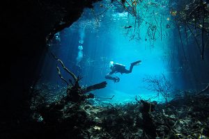
The ardent 53-year old explorer, diving instructor, conservationist, geospatial scientist, mapmaker and founder of El Centro Investigador del Sistema Acuífero de Quintana Roo, aka CINDAQ—whose mission is to facilitate research, promote education, and support conservation of the cenotes and underground rivers of Quintana Roo, Mexico,has spent more than a quarter of a century peering off into the darkness and returning to tell the tale. In CINDAQ’s case, this typically takes the form of map data, logs, pictures, photogrammetry, geospatial data, video, film, and documentaries (BBC, CNN, National Geographic and PBS), lending support to famed explorer Bill Stone’s observation that “the difference between exploration and adventure is data!”
In that regard, Meacham and his pioneering colleagues, Fred Devos and Chris Le Maillot, owners of Zero Gravity dive center, and others, have been extraordinarily prolific, shedding light on many hundreds of kilometers/miles of underground passageway that form the circulatory system of Riviera Maya, to the benefit of policy makers, scientists, and citizens alike. “We are building on the pioneering efforts of those who came before us and trying to build up the generation that will follow,” Meacham explained.


